From the first rapid assessment of a volcano's history to insights on geoengineering, the 15 June 1991 eruption of Mount Pinatubo changed the way we approach and learn from volcanic hazards.

On 3 April 1991, Sister Emma Fondevilla, a missionary based in a native Aeta village on the flanks of Mount Pinatubo, on the Philippine island of Luzon, led a group of villagers to meet with scientists from the Philippine Institute of Volcanology and Seismology (PHIVOLCS). Fondevilla and the villagers told the scientists about a series of steam eruptions on the northwestern side of the mountain.
What unfolded next would change history. Somehow, against severe odds, scientists convinced officials to evacuate more than 65,000 people living in Pinatubo’s shadow. Their tireless efforts stand as one of the most successful hazard mitigation efforts of a large volcanic eruption.
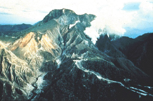
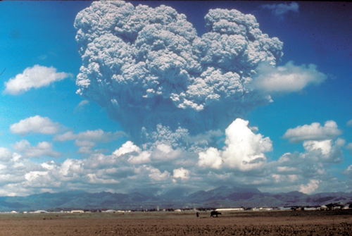
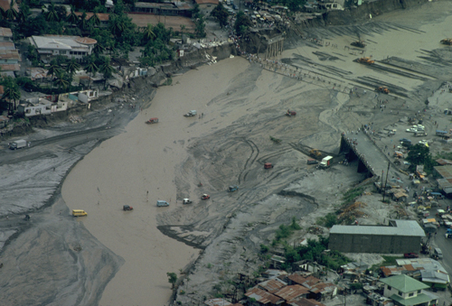
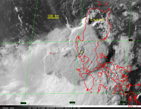
On 15 June at approximately 1:42 p.m. local time, Pinatubo erupted—the largest volcanic blast since Alaska’s Novarupta in 1912. Its ash cloud contained 5 cubic kilometers of material—lofted to 40 kilometers high. Because a passing typhoon simultaneously brought heavy rains, fast moving flows of ash, mud, and volcanic debris called lahars rushed down the volcano, flattening towns, smashing through jungle, and smothering rice paddies and sugarcane fields. The water also mixed with falling ash, creating a cement-like substance, and many buildings caved in from the weight. More than 350 people diedduring the eruption, most from collapsing roofs.
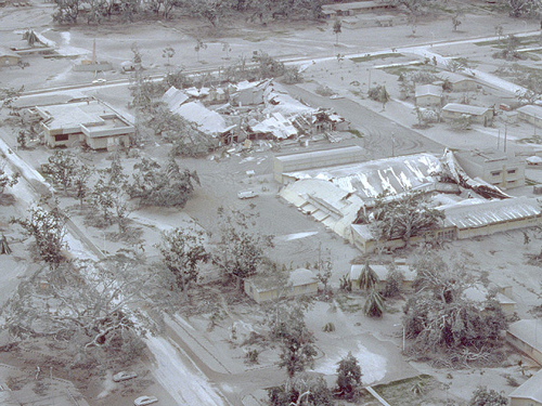
Effects from Pinatubo didn’t end on that date 25 years ago. Gas from the ash plume jostled weather patterns and dampened the effects of global warming for the next year. Lahars, which can run down a mountain after heavy rains, continued to pose threats to surrounding populations more than a decade later.
Pinatubo’s eruption broke ground, literally and figuratively. Here are eight ways that Pinatubo changed the way we approach and learn from volcanic hazards.
1. First Rapid Scientific Assessment of a Volcano’s History
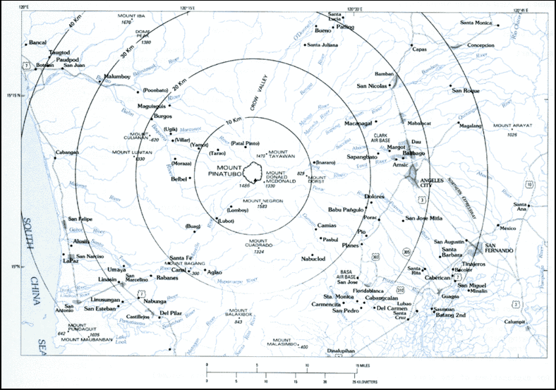
Once Pinatubo started rumbling, PHIVOLCS set up three seismometers on its northwestern flank. After U.S. Geological Survey (USGS) scientists—part of the Survey’s Volcano Disaster Assistance Program (VDAP)—arrived on 23 April, they set up a seismic network of seven stations located between 1 and 19 kilometers away from the volcano. Throughout May, seismometers recorded at least 200 small earthquakes per day.
A helicopter-mounted spectrometer—a device originally developed to monitor emissions from smokestacks—tracked dramatic increases in sulfur dioxide emissions from vents. Gas escapes as magma rises within a volcano, so this sign of moving magma, along with increasing seismicity and deformation measured by tiltmeters, led scientists to believe that an eruption was imminent.
One of the first things the VDAP team did was consult the catalog of active volcanoes from the Smithsonian Institution’s Global Volcanism Program. Pinatubo wasn’t even it in it at the time, Ewert said.
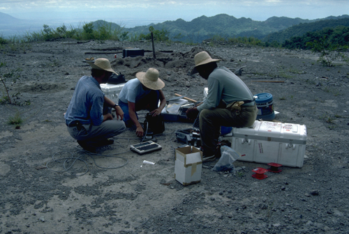
VDAP scientists wasted no time. They studied layers of ancient pyroclastic flows and lahars surrounding all sides of the volcano. They collected and dated samples of charcoal. They flew in helicopters around the volcano, mapping the extent of past flows and visiting outcrops.
From the air, the scientists saw that pyroclastic flows appeared “high up on ridges, or over ridges that would have blocked all but the largest flows,” Chris Newhall, a volcanologist who was a part of the VDAP team in the Philippines, told Eos. The observations confirmed how large the impending eruption could be.
From these studies the scientists figured out that the volcano had exploded in at least six eruptive periods over the past 5000 years, short bursts of activity followed by long, quiet periods. The most recent eruption occurred 500 years ago. What’s more, surrounding villages were built on old pyroclastic flows and lahars.
2. First Successfully Mobilized Widespread Evacuations
By early June the sulfur dioxide emissions dropped sharply to around 250 tons per day. Scientists suspected this meant that the viscous, rising magma had pinched shut cracks or had cooled and lost volatiles, either way preventing gas from escaping.
Around the same time, earthquakes within Pinatubo increased in strength and duration. In early June the earthquake clusters moved from northwest of the volcano to just under its summit. On 7 June a lava dome started to surface, and on 10 June, sulfur dioxide emissions jumped to more than 13,000 tons per day. Over the next few days, explosions—some generating columns of ash and debris up to 24 kilometers high—shook the volcano.
These signs pointed to one thing: The volcano was about to blow. But how could scientists convince the nearly 1 million people living around the volcano that they may need to evacuate?
The stakes were high: Just 6 years earlier, Nevado del Ruiz in Colombia erupted and killed more than 23,000 people. A “breakdown of communications” among scientists and local authorities was partly to blame, Ewert said.
In just a few weeks, PHIVOLCS and VDAP scientists had to interpret all the data they gathered about the volcano’s eruptive history and mold it into a simple warning scheme. The scheme had to be effective and easily digestible—enough so that they could convince tens of thousands of people living around the volcano, who spoke several different dialects and even different languages, to evacuate.
The team persevered, gathering local leaders of cities, towns, and small villages to explain the dangers and answer questions. Part of this educational campaign involved showing gruesome video footage from the Nevado del Ruiz tragedy that depicted destructive ash flows, volcanic mudflows, ashfalls, landslides, lava flows, and more. Though the scientists were concerned about overstating the hazards, in the end they “judged then (and still judge) that strong images were needed to awaken the population,” reflected PHIVOLCS and USGS scientists in 1996.
Here scientists learned a powerful lesson in hazard mitigation. As Ewert explained, “Showing people what had happened in other places in the world was much more effective than a scientist standing up in a crowd trying to explain it with interpretive dance and hand gestures.”
By early June, officials called for the evacuation of 25,000 people living in the area, including American service people at Clark Air Base and the U.S. Naval Station at Subic Bay. “By June 14 the recommended evacuation radius was 30 kilometers, which would have applied to perhaps 400,000 people,” Newhall said. Never before had such a widespread evacuation attempt been made before a volcanic eruption.
By the time the volcano erupted on 15 June, scientists and public officials had convinced more than 65,000 people to evacuate. More than 350 died during the eruption, but USGS and PHIVOLCS estimate that evacuation efforts saved between 5000 and 20,000 lives.
3. Importance of Effective Communication
In 1991, scientists had to look up information in books, make photocopies, and fax information to each other, Ewert said. This was a time before GPS and before data could be sent via satellite. Smartphones were science fiction.
In an era without a 24-hour news cycle, scientists at PHIVOLCS and USGS couldn’t supply the local populations with minute-to-minute updates, much less day-to-day, and rumors spread. One of these rumors claimed that a 3-mile-long fissure had formed after the eruption and that the nearby city of Olongapo would soon be hit by a giant lateral blast.
“Cellular telephones helped briefly, as long as their batteries lasted,” PHIVOLCS and USGS scientists reflected in 1996. “But it was not until June 16 that we could tell the country that a caldera had already formed and that the climax of the eruption had probably passed.”
Today’s advanced tools would have been helpful, but “in the end, for successful natural hazard mitigation, it all comes down to how effective scientists and public officials are at communicating with each other and the public,” Ewert told Eos.
4. New Understanding of Triggers for Eruptions Involving Multiple Types of Magma
After the blast, investigations of cooled lava revealed that the eruption involved a mix of different types of magma, a phenomenon that had been seen before but wasn’t fully understood. Scientists had been aware of mixed-magma eruptions, but they weren’t sure what triggered them, Ewert said.

Magma can be classified into types that distinguish how much silica they contain and how viscous they are, among other characteristics. Basaltic volcanoes, like those on Hawaii, have less viscous, “runny” magma pools. Silicic magma—made of dacite or rhyolite—is stickier and more viscous. It holds more gas that when depressurized, erupts more explosively.
Studies of lava deposits after Pinatubo exploded revealed something curious: minerals juxtaposed that would not normally coexist together had magma come from one source, Newhall explained. Thermal signatures—for example, crystals partially resorbing, chemical diffusion between crystals—suggested that magma was initially a mix of basalt and dacite prior to the eruption. But by the end of the eruption, magma was fully dacite.
Basalt magma is denser than dacite, so based on density alone, “the basalt should have been trapped beneath the dacite,” Newhall said. Instead, it rose into the dacite and mixed with it. But how?
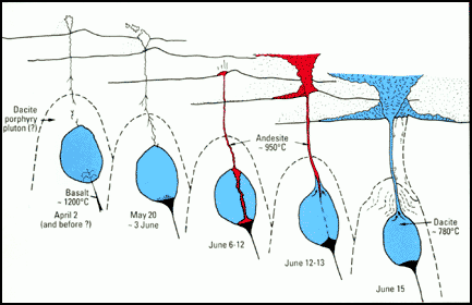
First, when the fresh, water-rich, and considerably hotter basalt hit the cooler dacite reservoir, the basalt crystallized, Newhall explained. That squeezed the basalt’s water and other dissolved gases into the remaining melt. Rather than remaining confined, the volatiles escaped from the melt and “formed tiny bubbles that decreased the density of the overall basaltic magma,” Newhall said. “So it was buoyant and rose into and mixed with a small amount of the dacite. That added even more volatiles.”
The resulting slurry was still less dense than its surroundings, so it kept rising and was the first erupted. Eventually, the dacite itself heated enough to rise to the surface and erupt.
This magma mixing manifested as subtly rumbling quakes that at times lasted about a minute long, called deep long-period (DLP) earthquakes. Long-period earthquakes indicate that magma is intruding into surrounding rock, but scientists had more frequently observed these events at depths less than 10 kilometers. Before Pinatubo, DLP earthquakes had been rarely observed and were not fully understood.
Nowadays, DLP earthquakes are “something we look for if we have a volcano that’s waking up,” Ewert said. Such a signal gives scientists clues into movements within the volcano’s plumbing.
5. Discovery That More Gas Erupts Than Studies of Rocks Can Reveal
Until Pinatubo, scientists assumed that the amount of gas a volcanic eruption released—mainly water vapor, carbon dioxide, and sulfur dioxide—was governed by the volume of magma erupted and the saturation levels the gas could reach within the magma, depending on the magma’s temperature. Collecting this information involves studying crystals of cooled lava after an eruption, Ewert said.
But what scientists found at Pinatubo by directly studying emissions was that “there was far more sulfur gas emitted in the atmosphere than could be accounted for” by studying crystals, Ewert said. This implied that emissions of water vapor and carbon dioxide—the gases that dominate emissions—were also more than scientists expected.
Before Pinatubo, scientists thought that gas that couldn’t be dissolved into the magma escaped through vents to the surface. But a whopping 17 megatons of sulfur dioxide was released by the explosion, as measured by satellite spectrometer. This implied that large amounts of gas could accumulate as bubbles and remain in the magma chamber, Newhall explained
Because this excess gas makes an eruption more explosive, it might even be that such free gas is required for a Pinatubo-like eruption, Newhall said. If volatiles are already in excess, they can expand immediately once the pressure drops, without any delay from diffusing through melt.
Knowing that magmas can hold excess gas can help with forecasting efforts, Newhall explained. For example, if a volcano has been plugged since its previous eruption yet has been continuously recharged with fresh magma and gas from depth, scientists can examine the time between its eruptions to gauge whether the volcano has accumulated enough excess gas to make it particularly explosive.
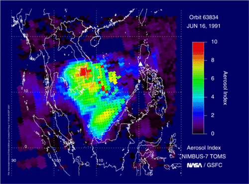
6. Illumination of Details About Atmospheric Circulation
The total amount of sulfur dioxide released before and during the eruption caused the most profound effect on the stratosphere since Krakatau in 1883. The sulfuric aerosols that formed from the sulfur dioxide circled the Earth within 3 weeks and remained in the atmosphere for 3 years, reflecting enough sunlight to cool the entire planet by half a degree Celsius during that time.
However, during the following winter, Europe experienced surprisingly warm temperatures. This winter warming hadn’t been observed after past volcanic eruptions, like Mexico’s El Chichón in 1982. What could be going on?
Using atmospheric circulation models and computer simulations to study how Pinatubo’s sulfur aerosol cloud traveled around the globe, scientists found that sulfuric aerosols reflect sunlight outward while absorbing heat from below, leading to cooling of the troposphere while heating the lower stratosphere, explained Alan Robock, an atmospheric scientist at Rutgers University in New Brunswick, N.J.
This temperature gradient strengthened the Arctic Oscillation, a wind pattern circling the Arctic. In its strong phase, the Arctic Oscillation pulls warm air from the ocean, heating northern Europe and shifting northward the global jet stream—the “river” of wind that flows around the globe.
The shifted jet stream allowed warm winds to flow over the Northern Hemisphere during the winter, Robock said. Because the jet stream flows like a wave, while Europe was receiving warm air from the south, the Middle East received colder air from the north, bringing to Jerusalem the worst snowstorm in 40 years.
“At the time of the Pinatubo eruption, nobody knew about winter warming,” Robock said. Armed with advances in modeling, plus the highly monitored atmospheric effects from Pinatubo’s eruption, atmospheric scientists are better prepared to forecast the global effects of the next big eruption, Robock added.
7. A Bolstered Case That Humans Cause Global Warming
The eruption helped scientists definitively declare that human emissions of greenhouse gases are to blame for at least the past 60–70 years of warming.
Scientists tracked sulfur aerosols sourced from Pinatubo’s eruption as they traveled around the world. For 2 years following the blast, surface temperatures cooled, as forecasted by climate models that included Pinatubo’s injections into the atmosphere. Temperatures rose again once the cooling aerosols fell out of the atmosphere.
This observation helped climate scientists sharpen their models further, confirming that humans—and the unprecedented amounts of greenhouse gases they pump into the atmosphere every year—are to blame for the warming climate. The Intergovernmental Panel on Climate Change was able to use these newly sharpened models to further support the attribution of climate change to human activities.
8. More Weight to Arguments Against Geoengineering
Some scientists have suggested hacking into our own atmosphere to counteract the effects of climate change, but Pinatubo’s eruption raised great concerns over whether such direct manipulation could be controlled. Known as “geoengineering,” one of these methods would involve injecting sulfur dioxide particles into the atmosphere just like a volcanic eruption would.
Robock and other scientists agree that this kind of injection would have negative consequences. One consequence is the destruction of the atmosphere’s ozone layer, which prevents dangerous ultraviolet rays from hitting Earth.
Robock said that to halt global warming, humans would have to inject 100 million tons of sulfur dioxide into the atmosphere every year—that amounts to about five Pinatubo eruptions per year. Scientists generally agree that the consequences of geoengineering are too risky to attempt. It would be safer and more practical to reduce carbon dioxide emissions and “keep fossil fuels in the ground,” Robock said.
Pinatubo’s Legacy
In 1996, USGS and PHILVOLCS scientists wrote this sobering reminder of how, if factors had been different, disaster may not have been averted at Mount Pinatubo: “In hindsight, we should have been less concerned about overstating the hazard and more concerned about speeding preparations for evacuations. Pinatubo almost overtook us.”
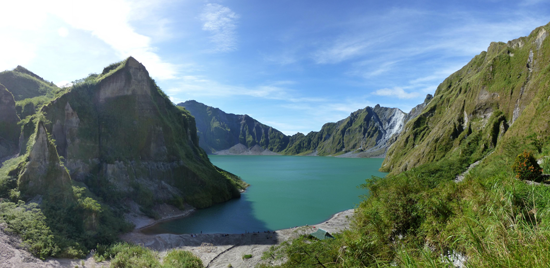
Mount Pinatubo, for now, stands relatively quiet, some 300 meters shorter than it was before it exploded 25 years ago. What might the next 25 years bring to Pinatubo? Time will tell.
—JoAnna Wendel, Staff Writer; and Mohi Kumar, Scientific Content Editor, Eos.org
Citation: Wendel, J., M. Kumar, and AGU Webmaster (2016), Pinatubo 25 years later: Eight ways the eruption broke ground, Eos, 97, doi:10.1029/2016EO053889. Published on 09 June 2016.
© 2016. The authors. CC BY-NC-ND 3.0
Tidak ada komentar:
Posting Komentar